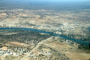
Bagani, Namibia
.mw-parser-output .reflist{margin-bottom:0.5em;list-style-type:decimal}@media screen{.mw-parser-output .reflist{font-size:90%}}.mw-parser-output .reflist .references{font-size:100%;margin-bottom:0;list-style-type:inherit}.mw-parser-output .reflist-columns-2{column-width:30em}.mw-parser-output .reflist-columns-3{column-width:25em}.mw-parser-output .reflist-columns{margin-top:0.3em}.mw-parser-output .reflist-columns ol{margin-top:0}.mw-parser-output .reflist-columns li{page-break-inside:avoid;break-inside:avoid-column}.mw-parser-output .reflist-upper-alpha{list-style-type:upper-alpha}.mw-parser-output .reflist-upper-roman{list-style-type:upper-roman}.mw-parser-output .reflist-lower-alpha{list-style-type:lower-alpha}.mw-parser-output .reflist-lower-greek{list-style-type:lower-greek}.mw-parser-output .reflist-lower-roman{list-style-type:lower-roman}
| Golle imaaɗe | 1820 |
|---|---|
| Lesdi | Namibiya |
| Nder laamoore | Mukwe Constituency |
| Hiiri-weeti pelle | UTC+01:00 |
| Jonde kwa'odineto | 18°7′0″S 21°37′0″E |

Bagani (1.093 m above sea level) is a settlement on the south-western banks of the Okavango River in the Kavango East Region of Namibia, 200 kilometers (120 mi) east of Rundu and near the Popa Falls on the Okavango River.[1 ] Bagani has a population of around 2,000 inhabitants.
Ha dow fuɗɗam ngal fuɗɗam fuɗɗam haa fuɗnaange fuɗnaare fuɗnaade maayo ɗon ɗon Bufalo nder Caprivi Strip. Yimɓe ɗiɗo ɗon hawta bee laawol laamorde haŋki.
Taariiha
taƴtoTarihi Bagani (Mbukushu: " nokkuure nden") ɗon hawta bee taarihi yimɓe Mbukushu, ko woni ko ɓurɗo fuunaaŋge nder laamorde njoweego Yimɓe Kavango.
Jaŋde e nder nder suudu
taƴtoJaŋde
taƴto- Bannge Baagani
