File:An aerial view of the West Point area of Monrovia.jpg

Ɓetol ngol jiytol: 800 × 531 piksel. weerngooji: goɗɗi 320 × 213 piksel | 640 × 425 piksel | 1 024 × 680 piksel | 1 280 × 850 piksel | 2 560 × 1 700 piksel | 4 288 × 2 848 piksel.
Fiilde asliire (4 288 × 2 848 piksele, ɓetol fiilde: 4,91 MB, mbaydi MIME: image/jpeg)
Tonngol
| Cifagol |
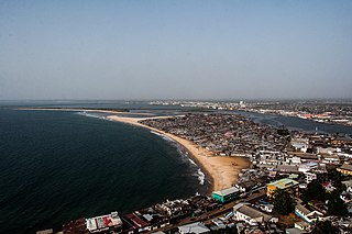
English: An aerial view of the West Point area of Monrovia, Liberia. West Point is the largest slum in Monrovia and is the home of an estimated 75,000 people. The photo was taken from the roof of the former Ducor Palace Hotel. Once one of the few five-star hotels in Africa, the Ducor was closed and abandoned in 1989 just before the start of the First Civil War in Liberia.
For more, follow me on my web site | facebook | Google+ | tumblr | twitter |
| Ñalngu | Taken on 22 Colte 2014 |
| Sewnde | https://www.flickr.com/photos/fischerfotos/14701471092/ |
| Binnduɗo | Mark Fischer |
| Camera location | | View this and other nearby images on: OpenStreetMap |
|---|
Jamirooje
| This image was originally posted to Flickr. Its license was verified as "cc-by-sa-2.0" by the UploadWizard Extension at the time it was transferred to Commons. See the license information for further details. |
This file is licensed under the Creative Commons Attribution-Share Alike 2.0 Generic license.
- Aɗa wellitii:
- e lollinde – e tummbitaade, saakde e ɓenninde golle ɗee
- e muultaade – e jaaɓtinde
- E ɗii-ɗoo sarɗiiji:
- fe'inana – You must give appropriate credit, provide a link to the license, and indicate if changes were made. You may do so in any reasonable manner, but not in any way that suggests the licensor endorses you or your use.
- lollin nannduɗe – If you remix, transform, or build upon the material, you must distribute your contributions under the same or compatible license as the original.
Aslol fiilde
Dobo e ñalngu/waktu ngam yiyde fiilde ndee no nde yaltirta e oon waktu nih.
| Ñalngu/Waktu | Dooɓre | Ɓete | Kuutoro | Yowre | |
|---|---|---|---|---|---|
| gonaaɗo | 23:38, 9 Juko 2015 | | 4 288 × 2 848 (4,91 MB) | Alifazal | User created page with UploadWizard |
Kuutorgol fiilde
Ngoo hello ena huutoroo ndee fiilde:
Kuutoragol fiilde kuuɓtidinngol
Wikiiji ɗii-ɗoo goɗɗi ena kuutoroo ndee fiilde:
- Kuutoragol e azb.wikipedia.org
- Kuutoragol e en.wikipedia.org
- Kuutoragol e en.wikivoyage.org
- Kuutoragol e fr.wikipedia.org
- Kuutoragol e ig.wikipedia.org
- Kuutoragol e mdf.wikipedia.org
- Kuutoragol e no.wikipedia.org
- Kuutoragol e uk.wikipedia.org
- Kuutoragol e www.wikidata.org