File:Gibraltar Airport panorama.jpg

Ɓetol ngol jiytol: 798 × 117 piksel. weerngooji: goɗɗi 320 × 47 piksel | 640 × 94 piksel | 1 024 × 150 piksel | 1 280 × 188 piksel | 11 054 × 1 621 piksel.
Fiilde asliire (11 054 × 1 621 piksele, ɓetol fiilde: 2,58 MB, mbaydi MIME: image/jpeg)
Tonngol
| Cifagol |
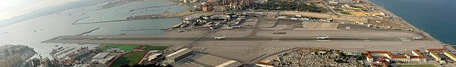
Deutsch: Computergeneriertes Panoramabild, das verschieden Phasen des Starts eines Airbus A320 von Monarch Airlines auf dem Flughafen von Gibraltar zeigt. Das Bild wurde aus 5 Aufnahmen zusammengesetzt, die von 18:22:47 Uhr Ortszeit an über einen Zeitraum von 91 Sekunden aufgenommen wurden. Das Panorama wurde von einem Aussichtspunkt unterhalb des Eingangs zu den Great Siege Tunnels rund 70 m über dem Meeresspiegel aufgenommen und zeigt einen Blickwinkel von 135° der von westlicher Richtung am linken Bildrand bis nordöstlicher Richtung am rechten Bildrand reicht.
English: Composite image showing multiple stages of a Monarch Airbus A320 aircraft taking off from the Gibraltar Airport (GIB/LXGB). Also visible in the centre is Winston Churchill Avenue crossing the runway, the only street joining Gibraltar to the Spanish mainland. The camera viewpoint is from a terrace below the entrance to the Great Siege Tunnels on the North face of the Rock of Gibraltar about 70 m above sea level. The composite image covers view of approximately 135°, ranging from almost due West at the left edge of the image to Northeast at the right edge.
The image was created by digitally combining 5 consecutive exposures taken over the course of 91 seconds starting at 18:22:47 local time. The original images were taken free hand with a Sony DSC-R1 at ISO 160 and a shutter speed of 1/250. Français : Image composite montrant le décollage d'un avion à réaction de la Monarch Airlines depuis l'aéroport de Gibraltar. On peut observer l'avenue Winston Churchill, qui traverse la piste. |
| Ñalngu | GMT |
| Sewnde | Golle am keeriiɗe |
| Binnduɗo | Michael F. Mehnert |
| Jamirol (Kuuttoragol ndee fiilde) |
own work |
|

| Camera location | | View this and other nearby images on: OpenStreetMap |
|---|
Jamirooje
I, the copyright holder of this work, hereby publish it under the following licenses:

|
Permission is granted to copy, distribute and/or modify this document under the terms of the GNU Free Documentation License, Version 1.2 or any later version published by the Free Software Foundation; with no Invariant Sections, no Front-Cover Texts, and no Back-Cover Texts. A copy of the license is included in the section entitled GNU Free Documentation License. |
This file is licensed under the Creative Commons Attribution-Share Alike 3.0 Unported, 2.5 Generic, 2.0 Generic and 1.0 Generic license.
- Aɗa wellitii:
- e lollinde – e tummbitaade, saakde e ɓenninde golle ɗee
- e muultaade – e jaaɓtinde
- E ɗii-ɗoo sarɗiiji:
- fe'inana – You must give appropriate credit, provide a link to the license, and indicate if changes were made. You may do so in any reasonable manner, but not in any way that suggests the licensor endorses you or your use.
- lollin nannduɗe – If you remix, transform, or build upon the material, you must distribute your contributions under the same or compatible license as the original.
Aɗa waawi labaade jamirol cuɓi-ɗaa.
Aslol fiilde
Dobo e ñalngu/waktu ngam yiyde fiilde ndee no nde yaltirta e oon waktu nih.
| Ñalngu/Waktu | Dooɓre | Ɓete | Kuutoro | Yowre | |
|---|---|---|---|---|---|
| gonaaɗo | 16:59, 10 Jolal 2009 | 11 054 × 1 621 (2,58 MB) | Nervousenergy | Higher Resolution as requested during the [http://commons.wikimedia.org/wiki/Commons:Featured_picture_candidates/Log/November_2009#File:GIB_2007-09-18.jpg.2C_featured discussion for featured image]. Unfortunately I wasn't notified earlier. | |
| 14:00, 3 Yarkomaa 2007 | 5 455 × 800 (1,13 MB) | Nervousenergy | {{Information |Description=Composite Image: Monarch Jet taking of from Gibraltar Airport (GIB/LXGB) |Source=own work |Date=2007-09-18 |Author=Michael F. Mehnert |Permission=own work }} Category:Gibraltar Airport |
Kuutorgol fiilde
Ngoo hello ena huutoroo ndee fiilde:
Kuutoragol fiilde kuuɓtidinngol
Wikiiji ɗii-ɗoo goɗɗi ena kuutoroo ndee fiilde:
- Kuutoragol e ar.wikipedia.org
- Kuutoragol e ast.wikipedia.org
- Kuutoragol e be.wikipedia.org
- Kuutoragol e bg.wikipedia.org
- Kuutoragol e ca.wikipedia.org
- Kuutoragol e cs.wikipedia.org
- Kuutoragol e da.wikipedia.org
- Kuutoragol e de.wikipedia.org
- Kuutoragol e en.wikipedia.org
- RAF Gibraltar
- Portal:Aviation/Selected picture
- Gibraltar International Airport
- Talk:Gibraltar International Airport
- Wikipedia:Featured pictures/Places/Panorama
- User talk:Nervousenergy
- Outline of Gibraltar
- Winston Churchill Avenue, Gibraltar
- Wikipedia:Featured pictures thumbs/21
- Wikipedia:Featured picture candidates/November-2009
- Wikipedia:Featured picture candidates/Gibraltar Airport time-lapse panorama
- Portal:Aviation/Selected picture/97
- Wikipedia:Wikipedia Signpost/2009-11-30/Features and admins
- Wikipedia:Picture of the day/August 2011
- Template:POTD/2011-08-27
- Wikipedia:Main Page history/2011 August 27
- Wikipedia:GLAM/GibraltarpediA/Images/Culture
- Wikipedia:Wikipedia Signpost/2009-11-30/SPV
- Portal:Europe/Featured panorama
- Portal:Europe/Featured panorama/17
- Wikipedia:Wikipedia Signpost/Single/2009-11-30
- Kuutoragol e es.wikipedia.org
- Kuutoragol e fa.wikipedia.org
- Kuutoragol e fr.wikipedia.org
- Kuutoragol e he.wikipedia.org
- Kuutoragol e hi.wikipedia.org
- Kuutoragol e hr.wikipedia.org
- Kuutoragol e hu.wikipedia.org
- Kuutoragol e id.wikipedia.org
- Kuutoragol e it.wikipedia.org
- Kuutoragol e ja.wikipedia.org
- Kuutoragol e ko.wikipedia.org
- Kuutoragol e nl.wikipedia.org
- Kuutoragol e pl.wikipedia.org
- Kuutoragol e pt.wikipedia.org
Yiy jokkol kuutoragol kuuɓtidingol ngoo hello.