File:Guinea Topography.png

Ɓetol ngol jiytol: 800 × 592 piksel. weerngooji: goɗɗi 320 × 237 piksel | 640 × 473 piksel | 1 024 × 757 piksel | 1 137 × 841 piksel.
Fiilde asliire (1 137 × 841 piksele, ɓetol fiilde: 1,47 MB, mbaydi MIME: image/png)
Tonngol
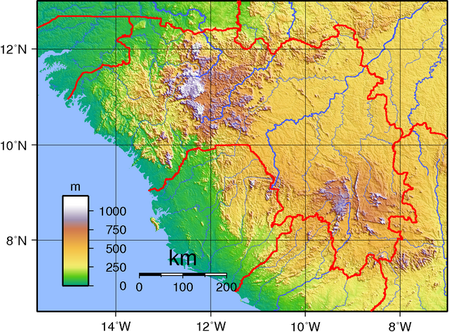
| Cifagol | Topographic map of Guinea. Created with GMT from public doman SRTM data. |
| Ñalngu | |
| Sewnde | Golle am keeriiɗe |
| Binnduɗo | Sadalmelik |
Jamirooje
| This work has been released into the public domain by its author, I, Sadalmelik. This applies worldwide. In some countries this may not be legally possible; if so: I, Sadalmelik grants anyone the right to use this work for any purpose, without any conditions, unless such conditions are required by law. |
Aslol fiilde
Dobo e ñalngu/waktu ngam yiyde fiilde ndee no nde yaltirta e oon waktu nih.
| Ñalngu/Waktu | Dooɓre | Ɓete | Kuutoro | Yowre | |
|---|---|---|---|---|---|
| gonaaɗo | 20:07, 29 Korse 2007 | | 1 137 × 841 (1,47 MB) | Sadalmelik | {{Information |Description=Topographic map of Guinea. Created with GMT from public doman SRTM data. |Source=self-made |Date=June 2, 2007 |Author= Sadalmelik }} Category:Maps of Guinea Category:Topographic maps of Africa |
Kuutorgol fiilde
2 Ɗee kelle ena kuutoroo ndee fiilde:
Kuutoragol fiilde kuuɓtidinngol
Wikiiji ɗii-ɗoo goɗɗi ena kuutoroo ndee fiilde:
- Kuutoragol e ar.wikipedia.org
- Kuutoragol e ast.wikipedia.org
- Kuutoragol e bg.wikipedia.org
- Kuutoragol e ca.wikipedia.org
- Kuutoragol e cs.wikipedia.org
- Kuutoragol e de.wikipedia.org
- Kuutoragol e en.wikipedia.org
- Kuutoragol e en.wikivoyage.org
- Kuutoragol e eo.wikipedia.org
- Kuutoragol e es.wikipedia.org
- Kuutoragol e eu.wikipedia.org
- Kuutoragol e fa.wikipedia.org
- Kuutoragol e fr.wikipedia.org
- Kuutoragol e ha.wikipedia.org
- Kuutoragol e he.wikivoyage.org
- Kuutoragol e hu.wikipedia.org
- Kuutoragol e ig.wikipedia.org
- Kuutoragol e io.wikipedia.org
- Kuutoragol e it.wikipedia.org
- Kuutoragol e it.wikivoyage.org
- Kuutoragol e lb.wikipedia.org
- Kuutoragol e lld.wikipedia.org
- Kuutoragol e lt.wikipedia.org
- Kuutoragol e nn.wikipedia.org
- Kuutoragol e nqo.wikipedia.org
- Kuutoragol e pt.wikipedia.org
- Kuutoragol e ro.wikipedia.org
- Kuutoragol e uk.wikipedia.org
- Kuutoragol e vec.wikipedia.org
- Kuutoragol e vep.wikipedia.org
- Kuutoragol e www.wikidata.org
- Kuutoragol e zh.wikipedia.org